
پرونده:Anglo-Saxon World Map Corrected.png

پروندهٔ اصلی (۱٬۸۲۷ × ۲٬۲۵۶ پیکسل، اندازهٔ پرونده: ۶٫۳۲ مگابایت، نوع MIME پرونده: image/png)
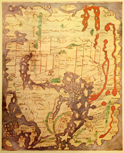
| توضیح | The 'Cotton' of Anglo-Saxon World Map (British Library; Cotton MSS, Tib. B. V, folio 56.; date probably about AD 1000) in color. Ceylon ("Taprobanea") is at top, Britain at lower left. Photographed from print, likely a book called "Atlas of Israel". |
| تاریخ | (UTC) |
| منبع | |
| پدیدآور |
user:Koyos; Original uploader was صانع القوالب at ar.wikipedia |
| دیگر نسخهها |
|


| این یک عکس دستکاری شده است به این معنی که به صورت دیجیتالی از نسخهٔ اصلی تغییر یافتهاست. تغییرها: Perspective, contrast, color correction. اصل آن را میتوان در اینجا مشاهده کرد: Gulf3..JPG. تغییرها توسط Koyos انجام شدهاست.
|
|
این اثر در کشورهایی و مناطقی که مدت زمان حق تکثیر، عمر پدیدآورنده بعلاوه 70 سال یا کمتر بعد از مرگ او است، در مالکیت عمومی قرار دارد.
| |
| این پرونده تحت قانون حق تکثیر محدودیت آزاد منتشر شده که شامل تمامی حقوق مربوطه و حقوق نزدیک به آن میشود. | |
سیاهه بارگذاری اصلی
This image is a derivative work of the following images:
- File:Gulf3..JPG licensed with PD-old
- 2008-03-17T13:59:07Z File Upload Bot (Magnus Manske) 2304x3072 (2027626 Bytes) {{BotMoveToCommons|ar.wikipedia}} {{Information |Description={{ar|''no original description''}} |Source=Transferred from [http://ar.wikipedia.org ar.wikipedia] |Date=2007-12-09 (original upload date) |Author=Original uploade
Uploaded with derivativeFX
تاریخچهٔ پرونده
روی تاریخ/زمانها کلیک کنید تا نسخهٔ مربوط به آن هنگام را ببینید.
| تاریخ/زمان | بندانگشتی | ابعاد | کاربر | توضیح | |
|---|---|---|---|---|---|
| کنونی | ۷ مهٔ ۲۰۱۰، ساعت ۲۳:۰۳ | | ۱٬۸۲۷ در ۲٬۲۵۶ (۶٫۳۲ مگابایت) | Koyos | {{Information |Description=The 'Cotton' of Anglo-Saxon World Map (British Library; Cotton MSS, Tib. B. V, folio 56.; date probably about AD 1000) in color. Ceylon ("Taprobanea") is at top, Britain at lower left. Photographed from print, likely a book call |
کاربرد پرونده
صفحهٔ زیر از این تصویر استفاده میکند:
کاربرد سراسری پرونده
ویکیهای دیگر زیر از این پرونده استفاده میکنند:
- کاربرد در fa.wikipedia.org
- کاربرد در ur.wikipedia.org