پرونده:Nile River and delta from orbit.jpg

Page contents not supported in other languages.
ویکی‎کتاب، کتابخانهٔ آزاد

Nile_River_and_delta_from_orbit.jpg(۷۰۰ × ۵۵۰ پیکسل، اندازهٔ پرونده: ۸۵ کیلوبایت، نوع MIME پرونده: image/jpeg)

این پرونده از ویکی‌انبار است و ممکن است توسط پروژه‌های دیگر هم استفاده شده باشد. توضیحات موجود در صفحهٔ توضیحات پرونده در آنجا، در زیر نشان داده شده است.

خلاصه

توضیح

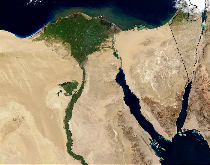
Nile River and delta from orbit Description: The Nile River and delta as seen from space by the MODIS sensor on the Terra satellite.

"Against the barren desert of northeastern Africa, the fertile valley of the Nile River runs northward through Egypt. In the higher-resolution images, the city of Cairo can be seen as a gray smudge right where the river widens into its broad fan-shaped delta. Other cities are dotted across the green landscape, giving it a speckled appearance. Where the Nile empties into the Mediterranean Sea (top) the waters are swirling with color, likely a mixture of sediment, organic matter, and possibly marine plant life. Farther west, the bright blue color of the water is likely less-organically rich sediment, perhaps sand.
"East of the delta lies the arid Sinai Peninsula, whose pointed tip is home to rugged mountains, some as high as 8,600 feet. The lattice work of pale lines marks the paths of ephemeral rivers. The Sinai Peninsula intrudes into the Red Sea. Farther east are Israel, Jordan, and Saudi Arabia. At top right is the disputed territory of the West Bank.
"In the false-color image, vegetation is bright green, water is dark blue or black, and clouds are light blue. It's interesting to notice that places that seem essentially arid, or desert-like in the true-color image in fact have a delicate layer of vegetation. For example, the central Sinai Peninsula, and most of Israel have a faint greenish tinge in the false-color images.
تاریخ
منبع http://visibleearth.nasa.gov/view_rec.php?id=4927 [1]
پدیدآور Jacques Descloitres, MODIS Rapid Response Team, NASA/sh
دیگر نسخه‌ها Cuaggjacgacugvajgca

Salchicha

اجازه‌نامه

Public domain این پرونده در مالکیت عمومی قرار دارد چرا که توسط ناسا ایجاد شده است. سیاست حق تکثیر ناسا بیان می‌کند که «مواد ناسا با حق تکثیر محافظت نمی‌شوند، مگراینکه ذکر شده باشد». (Template:PD-USGov، صفحهٔ سیاست حق تکثیر ناسا یا سیاست جی‌پی‌ال استفاده از تصاویر را ببینید.)
هشدارها:

عنوان

شرحی یک‌خطی از محتوای این فایل اضافه کنید
Nile delta

آیتم‌هایی که در این پرونده نمایش داده شده‌اند

توصیف‌ها

تاریخچهٔ پرونده

روی تاریخ/زمان‌ها کلیک کنید تا نسخهٔ مربوط به آن هنگام را ببینید.

تاریخ/زمانبندانگشتیابعادکاربرتوضیح
کنونی‏۲۹ نوامبر ۲۰۰۴، ساعت ۲۲:۴۷تصویر بندانگشتی از نسخهٔ مورخ ‏۲۹ نوامبر ۲۰۰۴، ساعت ۲۲:۴۷۷۰۰ در ۵۵۰ (۸۵ کیلوبایت)MschlindweinNile River and delta from orbit

صفحهٔ زیر از این تصویر استفاده می‌کند:

کاربرد سراسری پرونده

ویکی‌های دیگر زیر از این پرونده استفاده می‌کنند:

نمایش استفاده‌های سراسری از این پرونده.